this page contains more Mow Cop stuff, as listed below; for the chronological history of Mow Cop from 1189 to 1939 see the other Mow Cop page, and for Mow Cop family trees see the family trees page
• Mow Cop and the Erstwhile Realm from the Congleton Chronicle 1980-81 (immediately below)
• more to come
• A Historical and Topographical Portrait of the Mow Cop Locality from the Eastbourne exhibition booklet 1979 (further down, click to tumble)
• more to come
Mow Cop and the Erstwhile Realm
a series of four articles published in the Congleton Chronicle in 1980-81 as a tribute to Revd J. E. Gordon Cartlidge, stressing the importance of his contribution to the history of Mow Cop while also, where appropriate, providing commentary and criticisms; his long series of articles called “From Cloud to Mow” in the Chronicle of 1939-40 builds a history of the two hills around the idea that the ridge trackway along Mow Cop is part of a prehistoric trade route linking the Peak District and Shropshire; my articles are presented here re-typed, with any misprints corrected, some typographical conventions altered, and economising on commas, but otherwise resisting the urge to revise or improve them – instead a newly added Postscript contains a handful of updated interpretations, plus a brief account of how I first came to read Cartlidge’s articles
Mow Cop and the Erstwhile Realm
A four part feature looking at aspects of the history of the Mow Cop ridge with special reference to the writing of the Rev. J. E. Gordon Cartlidge in the Chronicle of 40 years ago. The views expressed are those of Mr. A. V. Simcock, himself a native of Mow Cop.
Part One
“Defiant stand the hills of Cloud and Mow.
Twin guardians of some erstwhile realm long past,
Grim outposts reared to check invaders’ haste,
Their forts enveloped oft in cloudy haze,
Guarded by spirits of men in cairn-like graves;
And twixt the two, an eerie ridge path ran,
Worn by the footprints of every age of man ...”
The Rev. John Edward Gordon Cartlidge, from whom these lines are taken, died towards the end of 1976 at the age of 94. The Chronicle described him at the time as the Congleton district’s “most noted and respected historian” [Chronicle, Dec 3, 1976].
Mr. Cartlidge was chiefly concerned with what might be called the obscure fringes of local history – streams, woodlands and routeways, ancient British archaeology and religion, minor Roman activity, lost features of the prehistoric and medieval landscape, and outlying places with little historical documentation, such as The Cloud and Mow Cop.
The published works of the Rev. Gordon Cartlidge include his book Newbold Astbury and its History (1915); a leaflet on Astbury Church, which is still available; and numerous contributions to the Chronicle over many years, especially in the 1930s and 40s.
Among other subjects on which he was an authority, he wrote about the Lyme forest which formerly covered part of this region, produced potted histories of the rivers and streams of the Congleton-Astbury area, reported and interpreted many local archaeological finds, and followed “the footprints of every age of man” over The Cloud and the Mow Cop-Congleton Edge ridge.
But again and again he returned with fascination to the “erstwhile realm” of prehistoric and Roman Britain, and to his reconstruction of its landscape and society in the vicinity of the two hills. This is to be found particularly in a series of articles entitled “From Cloud to Mow” – a masterly survey of local history based upon the hypothetical to-ings and fro-ings of generations of people along an ancient trackway running between the two hills.
With the arrival of the Romans (according to Mr. Cartlidge’s thesis) this trackway became a strategic line of communication, and the Cloud and Mow Cop became “outposts of the hill-tribes”, holding out for a significant if short period. On each, he believed, were situated a hill-fort and a much older religious or sepulchral monument.
The Cloud’s religious site is the Bridestones – a Neolithic chambered burial which, in its original form, was covered by an enormous cairn of Millstone Grit boulders in the form of a long barrow. Cloud’s alleged hill-fort also still remains, near to the summit of the hill, though whether this strange enclosure is a fort, or even a genuine antiquity at all, is still a matter of opinion, and local archaeologists tend to dismiss it.
Roman way?
But the archaeologists also doubted that the remains at Bent Farm, Astbury were, as Mr. Cartlidge had always known, a Roman camp, until recent excavations proved the site.
And they remain unconvinced by the evidence for the old lane which runs through the Bent Farm camp being a minor Roman road. Its course is traceable from just east of Middlewich, to Nick i’th’ Hill, and is aligned for most of the way upon Mow Cop. At Bent Farm it turns slightly in order to ascend the lowest point of Congleton Edge, where (at Nick i’th’ Hill) it intersects the older ridge way.
One only has to visit Bent Farm to see that the camp here was situated to command at the same time both The Cloud and Mow Cop, which suggests that it was established during a march east across Cheshire, as part of a strategem to assert Roman control over the two hills and their economic, religious and strategic assets.
It is also a matter of contention as to whether the trackway along the Mow Cop ridge can truly be regarded as prehistoric; but Mr. Cartlidge’s arguments are valid for the local section even though the evidence for the whole route is, inevitably, inconclusive.
Following the track to Mow Cop hill itself, however, one comes to his most obvious error – the placing of a hill-fort there, as well as on The Cloud. He made this supposition entirely from a dubious form of a place-name; there was, in fact, no such fort. But this does not alter the feasibility of seeing the hills as twin strongholds of the “erstwhile” Celtic realm. For Mow Cop was a sacred place, and had been from at least Neolithic times – a sacred precinct, with more or less precisely defined boundaries, enclosing the summit, where festive religious gatherings of the surrounding population took place.
The pre-eminent feature of this hilltop, before the existence of the present Tower and Old Man, was a cairn, described about 1530 as “a roke of stones that of old time have been reared”. Mr. Cartlidge, with more than a little historical intuition, believed its site to be that now occupied by the Old Man of Mow, so that, prior to quarrying, the cairn stood on the surface of which the top of the Old Man is a remnant. He further claimed this as the reason why the quarrymen left the rock – in order to replace the earlier landmark. My own researches have since confirmed that the site of the cairn was indeed that of the Old Man. And Cartlidge may have been right in regarding this ancient summit feature as a megalithic burial mound, like the original Bridestones.
Obstacles
There is no evidence to show that hill-forts were in any sense bases of Celtic military strength. What have traditionally been termed ‘forts’ seem to have originated as defensive enclosures, as much for animals as for humans, and in connection with native tribal disputes or brigandry. Indeed, if one accepts the well-known view that the cultural leaders of the native British, and the chief advocates of resistence to the Romans, were the Celtic priesthood (the Druids), then one might see a holy mountain as the truest sort of ‘guardian’ of the old order, the most likely ‘outpost’ of resistence to invasion. And in fact, the explanation of a ritual enclosure suits the earthworks on The Cloud much better than the idea of a hill-fort. Hence Mr. Cartlidge’s general hypothesis can still be taken seriously. Anyway, the very nature of Cloud and Mow made them, at the least, topographical obstacles to the imposition of Roman rule, and obvious places for a harrassed native population to retreat to.
But there was something more to Mr. Cartlidge’s view than this. The mystery which pervades the lines of verse quoted at the beginning, with their juxtaposed images of firmness and fragility, the real and the ephemeral, arises from the mixing in them of an actual and a metaphorical meaning – the strongly suggested metaphorical meaning being that the hills are still “guardians of some erstwhile realm long past”, their remote and historic summits “enveloped” in a kind of timelessness, and inhabited by “spirits”. It is as though the two “defiant” hills have resisted the taming and progressive forces in history, as to an extent they have. But their timeless quality, their eeriness, and their strange “allurement” cannot be as easily defined as this.
An acceptance of the mystique of the hills, as a reality in itself, was an essential ingredient of the Rev. Gordon Cartlidge’s insight into local history, and the key to his originality and importance as a historian of The Cloud, Mow Cop, and the places which they “overshadow”.
Part Two
Most people familiar with Mow Cop agree that it is a fascinating and strange place. But historians have rarely been able to offer them more than a few well-worn scraps of information.
Most writers show a very imperfect understanding of the subject, as well as disagreeing on elementary matters of fact. The Cheshire historians Oliver Bott and Rhys Williams, who in 1975 wrote Man’s Imprint on Cheshire, called Mow Cop a “former mining village” [p.59]; while their colleague Dorothy Sylvester, in Field Excursions in North-West Midlands and Cheshire (1973), terms it a “Quarrying village” [pp.80-81].
To the authors of The National Trust Guide (1973), Mow Cop is just “a large and elaborate castle” [Robin Feddon & Rosemary Joekes, p.282]; while to Squire Rode back in the 17th century it was “a Stone Quarry”.
Robert Head’s Mow was 1,101 feet high, H. B. Kendall’s 1,091, Frank Porter’s 1,000 and Eilert Ekwall’s a diminutive 977 feet (following the authoritative Times Atlas). It has often been said that the name Mow Cop means ‘bald head’ but Head thought it meant ‘lofty summit’, and Ekwall suggested ‘hill of the cairn.’
There are some things here which it should be possible to get right. For instance, is Mow Cop a coal mining or a stone quarrying settlement? Miss Sylvester offers a very confident explanation of how the quarrying industry, stimulated by industrial and urban demand from the Potteries, led in the 19th century to the growth of a substantial village from what was originally a scatter of 18th-century huts.
But in fact the quarrying industry declined during the 19th century; the expansion of Mow Cop village at this time was due almost entirely to coal mining. A village had existed here, however, since at least the mid-17th century, its economy prior to the Industrial Revolution being based upon a combination of stone quarrying and subsistence farming (that is, crofting and the use of common land for the production of a family’s own food).
Records scattered
One of the difficulties regarding Mow Cop’s history arises from the documentary source material. It isn’t so much – as some people have supposed – that the place lacks historical records, but that such records are scattered among, for example nine sets of manorial documents, ten or more parish registers, seven Census enumeration books, and the miscellaneous possessions of several widely distributed record offices.
And because the hill formed only a small part of each of the districts covered by these groups of documents, the name Mow Cop is often not encountered in them at all, everything being subsumed under parish, township or manor names (such as Astbury, Brieryhurst, and Nether Biddulph).
Much even of the most sensible writing about Mow Cop has thus had to be based upon intelligent guesswork, or else has consisted of long-established accounts which are virtually legendary (like the story of the origin of Primitive Methodism).
Mow Cop’s most noteworthy historians, W. J. Harper (who published A Short History of Mow Cop in 1907) and the Rev. J. E. Gordon Cartlidge, made proper use of documentary, oral and archaeological sources; but they were also inspired by a kind of gut reaction to the place, and this was how they managed to get beyond the limitations of their sources.
Both of them based some of their most useful and original work, at least initially, upon intuition – that is, upon feelings rather than facts. But in the field of subjective emotion, there are discrepancies too, as is illustrated by the reactions of two highly distinguished observers of historical landscapes.
Visiting during the preparation of the book Chilterns to Black Country (1951), W. G. Hoskins found a “rather unlovely hill”, “its sides concealed by little brick houses and its top crowned by a ruined Gothic tower” [p.10]. He was, however, sensitive to the hill’s status as a landmark dominating the skyline for some miles around, and to its role as the birthplace of an appropriately rugged form of Dissent, and hence “a place of pilgrimage” [p.10].
At about the same time, researching his book The River Trent (1955), J. H. Ingram found a different Mow Cop – a “windswept hamlet” scattered with “hidden farms and old, half-forgotten halls”, where one felt “far removed from the ordinary world” [p.13]. Although disappointed by the miserable ditch that was Mow Cop’s claimant to be the source of the Trent, he was deeply impressed by the “remote, unworldly corner of the countryside” to which it had led him [p.13].
Magnetism
For all the difference in their views, Ingram and Hoskins noticed two of the major facets of Mow Cop’s mystique: the “unworldly” feeling at the hilltop of being “far removed” from ordinariness; and the hill’s dominance of a large tract of surrounding landscape – both as a constantly visible landmark, and as a viewpoint overlooking the area.
It is an awareness of these, and other, aspects of Mow Cop’s mystical quality, and an acceptance that its strange magnetism was a historical reality, which infused such validity and evocativeness into the Rev. Gordon Cartlidge’s portrait of the hill. And his intuition told him that its importance in the prehistoric and Roman periods had something to do with this mystique; and that, somehow, something from this remote era survived on the hilltop, and along the whole ridge, whether it could be pinned down archaeologically or not.
The single most important contribution which Mr. Cartlidge has made to our knowledge of Mow Cop relates to the very aspect of the hill about which other historians have had least to say.
His discovery, as we saw earlier, was that the Old Man of Mow had been left to replace an ancient cairn which occupied the site until the 16th century. He also pointed out that the Old Man had preserved the original summit of the hill, otherwise quarried beyond recognition, its top being the highest point of land on Mow Cop, somewhat over 1,100 feet above sea level.
It also seems likely, as Cartlidge claimed, that ‘the Old Man of Mow’ was originally the name of the cairn, and was transferred from it to its present successor. To take this theme further, since it was a sacred feature, one can regard the present Old Man as representing (in the archaic view) a core of exceptionally holy ground beneath where the cairn had stood, and at the theoretical centre of the holy mountain.
With the discovery of the cairn, we must suppose that in ancient and medieval times Mow Cop had equally as distinctive an appearence as it has today because of the Tower. Indeed, being itself about the size of the Tower or larger, the cairn must have been an even more commanding landmark.
Mr. Cartlidge had little to say about the Tower, which in contrast to the Old Man has been much written about; for the most part, he was prepared to accept it as an “artificial ruin” of no historical consequence. He did state on one occasion, however, that both the Tower and the Old Man were “attempts to perpetuate” the appearance and concept of the earlier summit landmark – an intuition more profound and accurate than Cartlidge himself perhaps realised.
Part Three
In the “erstwhile realm” of Celtic Britain, the Mow Cop and Cloud area was, it is supposed, part of the borderland between the Cornovian and Brigantian nations, and hence a strategic zone in tribal terms long before it became so from the Roman point of view.
The centres of Brigantian culture were in the Peak and the Yorkshire Pennines; and the Bridestones (erected over 2,000 years before, in the Neolithic period) seems to have taken its name from Bride, or Brigit, the tribe’s patron goddess.
The Cornovian territory consisted of Shropshire and the surrounding counties, with its capital at The Wrekin – one of the most prominent features visible from Mow Cop.
Linking the heartlands of these two tribal nations, the Rev. J. E. Gordon Cartlidge proposed the existence of a great “trade route”, Neolithic in origin, part of which ran along the Mow Cop-Congleton Edge ridge – the natural boundary in ancient times between the lowland swamps of Cheshire and the highland region of the Lyme forest.
An unmetalled section of the trackway can still be seen along the crest of Edge Hill (the southern part of Congleton Edge), running in places over solid rock. To the south, the route continues to Mow Cop itself, where it can best be understood as following the line of Congleton Road and Mow Cop Road as far as Mount Pleasant. From here it runs via The Hollow to Red Bull and Talke o’th’ Hill, where it becomes identical with the main Roman road for a while, before heading off towards Shropshire.
North of Edge Hill, Mr. Cartlidge believed that the track continued over the crest of the Edge, but this seems unlikely; it probably took a course similar to the modern road down the Cheshire side. At Dane-in-Shaw it joined the Earlsway (Reade’s Lane and Dial Lane), which it followed as far as the Bridestones. Beyond The Cloud, in Cartlidge’s view, it headed via Bosley and Clewlow Cross for the moors around Buxton.
Sacred place
Whether or not one accepts Mr. Cartlidge’s opinion of the national significance of this prehistoric highway, his arguments remain valid as the basis for a reconstruction of the local situation around Mow Cop. As well as being a route of great economic importance, Cartlidge saw it as a “Pilgrim’s Path” (travelled by people en route to major shrines, such as Arbor Low), and, in certain circumstances, as a military road. In the latter respect, Mow Cop’s strategic value is obvious, both as a vantage point and, perhaps, as a signal station.
I have already mentioned that Mow Cop was itself a sacred place; this is something which Cartlidge strongly implied, and my researches have established more definitely. Its main role as a holy place was as the scene of annual festive assemblies, which took place at Lammastide (around 1st August), the Celtic harvest feast, and a time of special significance on hills because it is the season of the bilberry – a sacred fruit – and of the blossoming heather, the flower of the mountains.
The economic assets of the Mow Cop ridge have always been its extractive industries. During Roman times, the three main materials were all probably being worked: stone from Congleton Edge and the summit of Mow Cop (chiefly for querns, that is, hand-millstones); limestone from Limekilns (for mortar); and coal from near to Moody Street, on the Biddulph side of the ridge (possibly for industrial use in Middlewich).
Neither Mr. Cartlidge’s belief that there was Romano-Britiah lime working on the Astbury slopes, nor my theory about the coal mining, have been proved, but the point that such valuable materials, available at outcrop, would surely have been exploited had their existence been known, seems to be no weak argument by itself. The stone at least had been worked since well before the Roman Occupation. Indeed, since querns were the only means of rendering the grain harvest edible, Mow Cop’s Millstone Grit was as much a factor in making it a sacred place as its water, which irrigated the fields where the corn grew.
The Roman conquest of Mow Cop (and The Cloud), is witnessed, as I asserted earlier, by the site of the Bent Farm camp. The temporary nature of this fortification suggests that it was part of a successful action aimed at imposing Roman rule upon the troublesome hill-folk to the east, or at least gaining control of their principal industrial and religious centres, and of places offering potential bases for resistence and guerrilla activity.
The strategy may well have been to march up from Astbury to Nick i’th’ Hill, cutting the native communications along the ridge way, and then to approach Mow Cop by means of this route. The people of the borderland were probably of uncertain tribal allegiance, a cross between Cornovian and Brigantian, and consequently not necessarily bound by the tribes’ submission to Rome.
Subsequent Romano-British activity on and around the ridge is demonstrated by the existence of several minor Roman roads. Two have been provisionally identified – the route referred to previously, from Middlewich to Nick i’th’ Hill via Bent Farm; and an isolated stretch, probably linked to this at Moody Street.
The latter may have led to a Romanised Celtic farmstead at Moody Street Farm, which would control coal working on the surrounding hillside. The area is only six miles from the nearest Roman town at Chesterton, and eleven miles from Middlewich, both of them civil and industrial settlements of considerable size. Mr. Cartlidge also traced a few possible roads around the Bent Farm camp, including one leading to the limestone outcrop at Limekiln Farm.
Finds
Among the most interesting archaeological finds from the Mow Cop ridge are a number of querns, and an “Etruscan” lamp. The latter appears to date from several centuries B.C., Mr. Cartlidge’s interpretation being that it was already something of an antique when deposited in the Roman period.
The querns unearthed in the Congleton Edge quarries in the 1930s include examples of Iron Age or Romano-British date. Many quern-like objects have been found on the summit of Mow Cop, some of them of very primitive appearance, though their apparently unfinished state makes them difficult to put an age to. These stones from Mow Cop were unknown to Cartlidge, and have not received the publicity accorded to the Congleton Edge group, though they are undoubtedly of greater importance.
Mr. Cartlidge was fond of the personal, human touch which archaeology provided. He wrote with affection of the “traveller” who lost “his treasured lamp on Mow Cop”, even on one occasion speculating that he may have been “on night shift” at the lime kilns. And he contemplated the generations of men who had returned home to their wives with “A present from Congleton Edge” – a quern.
In a more serious but equally romantic vein, he saw the Roman Occupation as the twilight of a rather grand era, with Celtic Iron Age society and culture at its peak being modified by the imposition of Roman military control, and then ousted completely by the Anglo-Saxon and Scandinavian settlements.
But locally, he believed, the old order had clung to Mow Cop and The Cloud, if only, in the end, as timeless memorials to this vanished age, “guardians” – at most of its archaeological remnants, such as they were; at least, to some extent, of its atmosphere.
Part Four
The Rev. J. E. Gordon Cartlidge’s series of articles “From Cloud to Mow”, in the Chronicle of 1939 and 40, is one of the most important things that has ever been written about this locality.
It is a sweeoping historical survey, tracing “the footprints of every age of man” along the ridge trackway from The Cloud to Mow Cop – “footprints” in the form of archaeology, place-names, folklore, documentary records, and all the other stuff of history.
The old road formed an ingenious backbone to the story, linking as it did widely separate generations, and even races, of people. And, like the two hills over which it passed, it seemed always to have exercised something of its own influence over these “travellers”.
Mr. Cartlidge’s imagination was chiefly aroused by the archaeological evidence, and hence by the prehistoric and Roman phases of the story, and only by the most novel and obscure aspects of later history – such as the origin of the Old Man of Mow.
The insights derived from his use of the trackway, however, shed new light on several unexpected topics. Even the evangelists of Primitive Methodism were portrayed as treading in the footsteps of centuries of followers of the old route. Some famous early camp meetings were in Shropshire, the earliest of them on The Wrekin; and the precise causes of the Wrekin meeting have never been satisfactorily explained. Cartlidge’s suggestion of a kind of established itinerary between the two mountains (Wrekin and Mow), originating with this prehistoric highway, is a valid and challenging idea.
One of the ways in which Mr. Cartlidge attempted to prove the ancient track, and shed light on prehistory generally, was by the interpretation of place-names. His Celtic etymologies of some names (such as Drumber Lane and Roe Park) were based upon similar names in Eilert Ekwall’s Oxford Dictionary of English Place-Names (1936), and cannot be taken seriously. Nevertheless, a number of points implicit in his treatment of place-names retain their relevance – the recurrence in the district of certain interesting elements, such as “cat” and “red”; the possible alternative or multiple meanings of apparently straightforward names like Overton, Nick i’th’ Hill, and the Old Man of Mow; the likelihood of unsuspected Celtic derived place-names existing among minor local names; and, at least, the awareness that an apparent Anglo-Saxon name could be a Saxon-isation of an older Celtic name with a similar sound but a different meaning, or a Saxon translation of the Celtic name.
Another Mow Cop
Ekwall’s Dictionary was an important inspiration to “From Cloud to Mow”, particularly since it suggested, with no real knowledge of the local situation, that the term “Mow” referred to “a boundary cairn” [The Concise Oxford Dictionary of English Place-Names, 1936, p.317]. Its publication came in the same decade as a number of archaeological discoveries in the area, and the appearance of the Lancashire and Cheshire Record Society’s volume of Star Chamber proceedings (volume 71) which contained the references to the Mow Cop cairn. These were among the mainsprings of Mr. Cartlidge’s thesis. The 1930s was also a time when much archaeological thought was devoted to the distribution of objects and sites, with the aim of discovering cultural and economic associations between different regions of pre-Roman Britain; and theories about “old tracks” and “trade routes” were very much in the air.
The work of Miss L. F. Chitty, on Shropshire, was relevant to our area, and proved useful to Cartlidge’s argument. He was especially excited by evidence which linked Cheshire and the Peak District with mid-Shropshire in prehistoric times, because he himself, though a native of Astbury, lived in Shropshire for much of his life.
This explains how he came to notice the 18th- and 19th-century entries in the Edgmond parish register which referred to people from “Mow Cop” or “ye Mole Cop”. He mistakenly took these to be gypsy-like itinerant labourers, migrating seasonally between Mow Cop and the Edgmond region, 25 miles away. In fact they came from a now deserted settlement near to Pickstock, in Shropshire, where there is still a Mow Cop Farm.
Even if, because of the vague nature of the evidence, one can never be totally sure about Mr. Cartlidge’s system of prehistoric routeways, his arguments still demonstrate much activity on and around Mow Cop in the prehistoric and Roman period, and the ridge trackway over Mow Cop and Congleton Edge is obviously authentic and important locally, whether or not it was part of a longer “trade route”.
So, although some of the contents of Mr. Cartlidge’s Chronicle writings have to be modified or even dismissed in the light of modern research, much in them can be accepted, and much else remains to suggest challenging and potentially fruitful areas of study. Indeed, paving the way towards further scholarly research was one of Cartlidge’s expressed aims. But he was also keen to communicate his romantic, imaginative and mystical feelings, and insisted on his readers retaining a “sense of wonder”.
Mystique
Not a little of what he had to say in “From Cloud to Mow”, and of the insight and intuition which so assisted him, was connected with what I have called the mystique of the two hills. Their “mysterious influence” upon those who have travelled over them or dwelt under them was his constant theme. And the recognition that they were holy places was implicit throughout.
The number and locations of Mow Cop’s springs suggested to him “that this hill with water at its summit was under the tutelage of the gods”; and the 17th-century account of persecuted Catholics meeting on the hilltop was “another indication of the peculiar spiritual pull and urge which for thousands of years have been associated with Cloud and Mow”. It is not irrelevant that the Rev. Gordon Cartlidge, apart from being a historian and archaeologist, was by vocation and profession a priest, as well as something of a poet.
The final two instalments of “From Cloud to Mow” took the form of a sermon-like essay and a long poem. In them, the prehistoric ridge way becomes the road of history, and disappears “into the dim distance of time and space”; while the two hills with ancient strongholds at their summits become themselves “fortresses of time”, “guardians” of the past and “watchmen” over humanity’s present, over “life’s highway”.
Mow Cop’s mystical quality, its “spiritual pull and urge”, has inspired painters, novelists, poets and, more significantly for history, religious mystics and revivalists – of which the Primitive Methodists were not the first (nor indeed the most recent).
One can appreciate and respond to Mow Cop as a romantic or as a scholar. But it is a controlled combination of both responses that allows the fullest appreciation of the history of the hill.
From such a synthesis sprung the Rev. J. E. Gordon Cartlidge’s outstanding contribution to local history, and in particular to the study of Mow Cop and the “erstwhile realm”.
[from The Congleton Chronicle, Dec 24, 1980, p.17 (Christmas issue), & Jan 2, 9, 16, 1981, pp.8, 10, 11]
Postscript 2025
These articles were a posthumous tribute to Revd J. E. Gordon Cartlidge (1882-1976), whose long series of articles “From Cloud to Mow” (22 parts, no less) appeared in the Congleton Chronicle in 1939-40 and inspired me in the early days of my local history studies, aged about 14 – no, I don't go back quite that far, I first read them in the Chronicle office in Congleton, where the editor John Condliffe let me spend days poring over the precious archive of back issues (and gave me a genuine Chronicle reporter’s notebook to make notes in). A few years later, I briefly corresponded with Cartlidge when he was in his nineties. After he died I wanted to write something that stressed the importance of his contribution to local history while also, where appropriate, making comments and criticisms. Needless to say what I wrote nearly half-a-century ago doesn’t entirely satisfy me now, though I’ve resisted the urge to revise or improve it (beyond correcting misprints). It certainly reads a bit woffly and repetitive, and the balancing act of paying tribute and criticising is sometimes laboured, though some of this is because it was serealised and thus written to be read in four chunks at weekly intervals. A handful of things (surprisingly few, I suppose) tempt me to revise or update, as follows.
I wouldn’t now agree that the summit cairn on Mow Cop is likely to have been a burial mound, nor that the name ‘Old Man’ (not found before the early 19th century) can realistically have come from the cairn, which disappeared two centuries before. In speaking of the ‘village’ of Mow Cop a distinction needs to be made between early settlement, which was very scattered and mostly on the mid and lower slopes, and the familiar hilltop village, which only came into existence with the colonisation of the common land in the 18th and early 19th century – quarrying was a factor at first, but coal mining increasingly provided the main employment. To the raw materials that were Mow Cop’s ‘economic assets’ I’d add iron ore, which was more valued than coal in most ancient societies (we’re speaking of the Iron Age, after all) and even down to the 17th century. I now think it more likely that the Roman-like road at Moody Street (Biddulph), in spite of its name (‘street’ meaning Roman road in Old English), is a medieval industrial road – industrialists whose heavy wagons loaded with coal or millstones (or iron ore) were forever getting bogged down (‘moody’ means muddy!) routinely causewayed ie raised and paved those stretches (though I stick with the related suggestion that some of the old farms on the hillside could be successors of Iron Age farms). And finally, I can’t imagine why I said the ‘quern-like objects’ found on Mow Cop are of greater importance than the Congleton Edge querns, that’s just silly.
TS 2025
A Historical and Topographical Portrait of the Mow Cop Locality
this text was written in connection with an exhibition of paintings and photographs shown at Eastbourne and Hove in 1979, and printed in a booklet that accompanied the exhibition; the idea was to provide a geographical and historical context for the landscape paintings of Jack Simcock – hence the digressions into Biddulph Moor and the Simcock family, stone heads and boulders, etc, as well as the relative neglect of the human side of local history; the account is presented here re-typed, with any misprints corrected and some economising on commas, but otherwise resisting the urge to revise or improve it – instead a newly added Postscript contains updated interpretations and information on some of the topics covered
A Historical and Topographical Portrait of the Mow Cop Locality
Mow Cop
At the north western edge of the Potteries Coalfield, between the Staffordshire Moorlands and the Cheshire Plain, rises a ridge of Millstone Grit, four miles long and broadening at its southern end into a mountain just over 1100 feet high. This is Mow Cop. The Cheshire side of the ridge, much of it still covered by the remains of an ancient tract of oak woodland, falls steeply to about 400 feet; the Staffordshire side falls more gently into the Biddulph Valley; and in the south a scatter of foothills lies between Mow Cop and the urban-industrial region comprising Kidsgrove, Newcastle-under-Lyme, and Stoke-on-Trent.
The change in the natural and historical landscape is apparent as one climbs the slopes of Mow Cop. Dry stone walls take over from hawthorn hedges; stone replaces brick or timberframe for the older buildings; in parts of winter the ‘snow-line’, and at any time of year the ‘mist-line’, can often be met with at about 800 feet; and as the soil thins towards the summit, the dairy pastures or low woodland give way to small crofts with coarse grass, and eventually to heathland on which heather and bilberry grow among banks of scree and outcrops of rock. In ancient times this summit protruded above the forest which then clothed the hillsides.
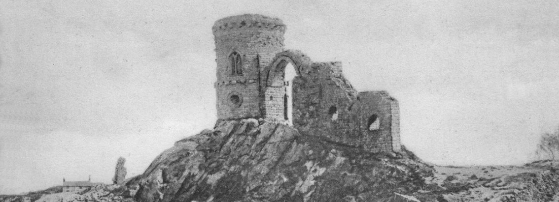
Much of the exposed rock is the result of several thousand years of quarrying – the earliest human activity that can be traced on the hill, and the dominant industry until the Industrial Revolution. The highest rocks nevertheless show themselves, by signs of great weathering, to be relics of the primeval outcrops [note 1] which attracted the first quarrying. Apart from the quarries, two other features formed by man have changed the prehistoric skyline of the hill. The Old Man of Mow, a huge pillar of rock left isolated in the middle of a quarry, is the less prominent; but the Tower, or Mow Cop Castle, is a distinctive landmark for many miles around, and the feature most generally associated with Mow Cop.
In the Middle Ages a vast area at the summit of the hill and all along the ridge formed a common, to which the inhabitants of surrounding parishes and manors resorted for the grazing of their animals, the gathering of food, fuel and building materials, and the exercise of other common rights. The wasteland and old quarries which still lie open at the hilltop, mostly around the Tower, are the remnants of this Medieval common. A series of old lanes radiating out from the hill originated as access roads to the common land; while on the common there were no established routeways, except for the road along the ridge, which may be of considerable antiquity.
Activity on and around Mow Cop in the Roman period is demonstrated by two stretches of minor Roman road [note 2] which have been provisionally identified – presumably parts of routes linking Mow Cop with the nearest Roman towns, Middlewich in Cheshire, 11 miles away, and Chesterton, only 6 miles away in Staffordshire. By this time stone was being quarried on the hill, chiefly for the production of querns (hand-millstones). The coal on the Staffordshire side of the ridge, and possibly limestone, which occurs on the Cheshire side, may also have been worked during the Roman occupation, if not before. In addition to this industrial importance, Mow Cop was significant in the earliest phases of its history for two considerations that often affect prominent hills – strategic, and religious.
The Tower
The Tower on the top of Mow Cop was built in 1754 by stone masons John and Ralph Harding, father and son. They were working under the patronage of Randle Wilbraham of Rode, the lord of the manor on the Cheshire side of the hill, who tradition states paid the Hardings in ‘leathern pennies’, a form of token money. It is also known that Ralph lost two fingers in an accident during the building of the Tower. Despite all this, the circumstances and purposes of its erection remain mysterious. Outsiders regard it as a ‘folly’, though it does not belong to the mainstream of follies either is style or in date. Mow Cop people have long accepted the explanation fostered by the Wilbraham family, that it was a ‘summerhouse’ built for the use of visitors to the hill; and ‘the Summerhouse’ was the name by which many generations knew it before the currency of the modern term, ‘the Castle’.
It appears to have been intentionally built on the county boundary, and therefore half on the property of the Sneyds of Keele, in Staffordshire. In 1850 the two squires engaged in a court action over the ownership of the building. Why this should have been necessary is unclear, since the principle of (more or less) dual ownership which the court upheld had already been accepted in practice for many years. Even during the period in the 18th century when Ralph Harding was employed as caretaker of the Tower by the Wilbrahams, another man, Isaac Mountford, held a twin or rival position on behalf of the Sneyds [note 3]. This raises doubts regarding Wilbraham’s true reponsibility for the construction of the Tower, particularly since its doorway and the main pathways up to it are on the Staffordshire side, and the nearest house, on the same side, was the official residence of Sneyd’s caretaker, not Wilbraham’s. But apart from these points, the Tower has associations in history and folklore which simply do not belong to this world of manorial folly or summerhouse building.
The 1754 Tower is not in fact the first tower or tower-like object to have decorated the summit of Mow Cop; and its true origin is to be found in its prehistory – in the landmarks of the Mow Cop skyline which have preceded it, and in the traditions relating to it which date from before 1754. These things are best understood against the background of the hill’s role as a holy place, the summit forming a sacred precinct which was the scene of religious assemblies and pilgrimages. Doubtless dating back to Neolithic times, the festive assemblies survived, though with less of their old pagan vigour, until the late 19th century. ‘Mow Wake’, as the event was known, was latterly held near the end of July, its original date being Lammas (August 1), the Celtic harvest feast and the greatest religious festival of the pagan calendar.
Apart from being a mountain, the characteristics which made Mow Cop a holy place, and relevant to this harvest celebration, were its stone – from which querns and similar instruments, the only means of rendering the grain harvest edible, were quarried; and its water – the River Wheelock, together with important tributaries to the Dane and one of the headwaters of the Trent, rise on Mow Cop and irrigate large amounts of agricultural land, especially in Cheshire. Lammastide is also a special time because it is the season in which Mow Cop’s own crop, the bilberry, is ripe, and in which Mow Cop’s flower, the heather, blossoms.
Gathering bilberries was one of the activities of the Wake, another being the faction fight, fought between Cheshire and Staffordshire men on the county boundary. Another was the adoration and ‘dressing’ of holy wells or springs, some of which are still to be seen around the village. A custom much less familiar than welldressing, though not confined to Mow Cop, was the erection of a ceremonial tower on the hilltop. The connection in Mow Cop folklore between the present Tower and a ‘beacon’, or festive bonfire, probably means that this ceremonial tower was set on fire at the height of the Wake. Mow Cop Castle only begins to make sense when it is seen as (whether Squire Wilbraham knew it or not) a replica in stone of this ritual tower, once erected annually on the hill. I shall say more of the Tower’s predecessors on the Mow Cop skyline when I refer to the history of the Old Man of Mow.
Mow Cop Village
On the upper parts of Mow Cop, all around the summit, there is now a very large village, with a population of several thousand. In addition, there is scattered settlement along the ridge and on the slopes, including several smaller villages: Congleton Edge near the north end of the ridge, Mount Pleasant and The Bank on the Cheshire slopes, and The Rookery at the foot of the hill on the Staffordshire side. The small village of Dales Green is geographically and historically inseparable from Mow Cop village.
The oldest identifiable settlement sites are the farmsteads on the mid and lower slopes, mostly Medieval in origin but some probably older. Their occupants worked dairy farms often of well over 100 acres. At 875 feet on the Staffordshire side is the highest of these, Mow House, whose possessors in the 17th century, the Podmore family, played an important part in the development of Mow Cop’s industries and the growth of the village. Usually uphill from the large farms, and on or near to the edge of the former common land, are the hill farms – humbler houses, with land varying from 30 acres to less than 10. One of these, Dales Green Farm, already existed in the middle of the 16th century, and was the centre around which, under the patronage of the Dale family, the village of Dales Green developed.
But the character of the main part of the village of Mow Cop is that of a squatters’ settlement – its ‘plan’ and appearance result from centuries of cumulative encroachment upon the common land. References to the prosperity of the quarries in the 13th and 14th centuries lead one to suppose that there was already a more or less permanent community here, consisting of the quarrymen and their families. By the mid-17th century a fair-sized village was in existence – partly on land of the Dales and Podmores, but much of it scattered across the old common [note 4]. Settlement by squatting continued well into the 19th century. Apart from slight overlaps where the county boundary was vaguely defined, the village up to that time remained entirely on the Staffordshire side of the hill. Its origin as a squatters’ settlement accounts for the sprawling, uncentralised nature of this part of the village, as well as for the characteristically irregular layout of the cottages, crofts and roadways.
The smaller Cheshire section of Mow Cop village, now well integrated with the rest, developed in quite a different way, as its appearance shows. It is a more concentrated and orderly settlement, with a rigid geometric layout of streets, crofts and houses. An industrial workers’ village of the second half of the 19th century, it was formed by speculative building on a large field known as Fir Close, which about 1850 was divided into blocks and sold off. Many of the houses here had crofts, but these were sizeable and rectangular; and although some of the streets are still unmetalled, most of them are straight and at right-angles to one another. The chief streets are Primitive Street and Top Station Road, part of the latter at a gradient of 1 in 3. The development of Fir Close had more in common with that of contemporary miners’ villages on the lower slopes and in the foothills of Mow Cop, than with the various phases of settlement which together form the ancient part of the village on the Staffordshire side.
West View
West View, Mow Cop, was built in 1906, mostly of brick but with an imposing stone frontage and stone chimneys, and with a range of stone and brick outbuildings consisting of coach house, stable and loft. It was built for a local businessman, Joseph Lovatt (1873-1945), by the firm of Lovatts of Biddulph Moor (3 miles away). This explains the stone chimneys, a rare feature on Mow Cop but common in Moorland architecture. The stone mason on the building was James Battersby, of Biddulph Moor, a great uncle of Jack Simcock, who now lives in the house. It stands at the edge of the Cheshire part of Mow Cop village, on Primitive Street.
Joseph Lovatt was a native of The Rookery, though his ancestors came from Biddulph Moor [note 5]. In 1902 he bought some land on Fir Close and established a bakery. He married into one of Mow Cop’s oldest families, the Hancocks, and lived at West View for 20 years – during which period he rose to become the most ruthless and successful capitalist businessman who has ever lived on Mow Cop. He continued buying property; and his crowning achievement came in 1918 and 1922, when, in two stages, he purchased the summit of the hill from its manorial owners, and set up a quarrying business on the land. By now he had become regarded as the owner of Mow Cop, and West View was for a time nicknamed ‘the Manor House’.
This was no arbitrary nickname, for Lovatt had in fact usurped the economic role within the village, together with the power and (as he perhaps failed to see) the responsibility, of the old manorial lords from whom most of his property was bought. He had also, less directly, taken over from the industrial gentry – the North Staffordshire coal and iron masters, whose influence in the Mow Cop community had collapsed with the slump of the 1880s. The Mow Cop to which Lovatt came in the 1900s was a village in the midst of severe economic depression – a situation which his entrepreneurship could have improved.
But instead the people of Mow Cop formed a growing dislike both of Lovatt and of his activities and methods, particularly resenting his apparent personal wealth, which they felt, because of his capitalist business techniques, was achieved at their expense. The last straw was his enclosure of the summit (including those parts which lie open even today) for quarrying purposes – which, apart from preventing the exercise of common rights and especially rights of way, began to alter dramatically the landscape of the hilltop. Agitated by certain political extremists within the community, notably the schoolmaster Frederick Ellis, the discontent came to a head in the now legendary Mow Cop Dispute of 1923-26 – a complex historical phenomenon which amounted to little short of a localised revolution against Lovatt and what he appeared to stand for. (An account of the Dispute occurs in Jack Simcock’s book.)
The Mow Cop Preservation Committee, which led the controversy, met in the Primitive Methodist Schoolroom, on the ground floor of the chapel at the top of Primitive Street. Its members were crushingly defeated and humiliated by Lovatt at a hearing in the Court of Chancery in March 1926, only two months before the General Strike. In the summer of that year the Lovatts left Mow Cop. Mrs. Lovatt’s brother, Charles Hancock, the village undertaker, followed them at West View, using the loft over the coach house, now Jack Simcock’s studio, for coffin making, and one of the front rooms of the house as an occasional mortuary chapel. Shortly before Lovatt’s death the house ironically was acquired by Harry Oakden, one of his leading adversaries during the Dispute 20 years earlier. In 1958 it was bought by Jack Simcock, who with the beginning of 1979 has lived at West View longer than any other occupant.
Primitive Methodism
Only a field away from West View is School Farm. Prior to its recent rebuilding it was one of Mow Cop’s oldest houses, dating from about 1669. With around 25 acres of land, at an average of 850 feet above sea level, it was a typical Mow Cop hill farm; and its tenants generally pursued agriculture as a secondary occupation to coal mining, or some craft or trade. It was owned for many years by the Odd Rode Schools Trust, who used the rent to help finance a charitable school down on the Cheshire Plain, and who in 1858 founded a school at the lower end of the farm’s land, Woodcocks’ Well School, which still serves the Cheshire side of Mow Cop.
It is well known that the Primitive Methodist Church originated on Mow Cop. Many of the events connected with this took place at School Farm during the tenancy of Joseph Pointon (1734-1808), a Wesleyan Methodist class leader. In 1800 and 1801 Pointon’s society found itself at the centre of a religious movement, which marked the beginning of the Harriseahead Revivals – the collective name for several revivals and much miscellaneous religious activity in North Staffordshire and adjoining parts of Cheshire. These Revivals led, in 1807, to the English Camp Meeting Movement, and this in turn led to the birth of a separate sect. Some of the promoters of the camp meetings were expelled from the Wesleyan Church in 1808, and began two years later forming their converts into independent societies. At about the same time, in 1810, William Clowes of Tunstall (1780-1851) was expelled for his support of camp meetings, and it was his followers, the Clowesites, who first seceded from Wesleyan Methodism, and thereby formed the original nucleus of the new sect. The Clowesites and the Camp Meeting Methodists amalgamated at Tunstall in 1811, and adopted the name of Primitive Methodists.
The central event in the early part of the Harriseahead Revivals was a service at School Farm, in the summer of 1801, conducted by one of the revivalists, Hugh Bourne (1772-1852). Bourne lived at Bemersley, 2½ miles from Mow Cop, and had become involved with the religious life of Harriseahead (the nearest village to the Staffordshire side of Mow Cop) whilst doing a series of carpentry jobs at local farms and collieries. He joined several other men from Harriseahead and Mow Cop in a campaign of evangelism, of which his first public sermon at School Farm was the high point. In defiance of established Methodist practice it was held out of doors, Bourne standing at the gable of the house. The great size of the congregation demonstrated the reputation which the Harriseahead Revivalists had already acquired. The event played a part in spreading revivalism to Biddulph Moor and to Kidsgrove, and was also one of the factors which led to the foundation of a Wesleyan society and chapel at Harriseahead.
The first English camp meeting took place on May 31, 1807, on the land immediately uphill from School Farm. Although not exactly ‘organised’ by anybody, its date was arranged at Harriseahead and its chief promoter was Thomas Cotton of Mow Cop. The main group represented in the congregation, and among the preachers, were the Independent Methodists and other Methodist dissidents from distant parts of Cheshire and South Lancashire – people who had been influenced by the evangelistic crusade of the American preacher Lorenzo Dow, whose flying visit to Harriseahead had sparked off the decision to have a camp meeting. The meeting itself fused the true American camp meeting with a native concept of having, as William Clowes recalled it, “a day’s praying and shouting” on top of Mow Cop. It is not easy to grasp the precise nature and origin of this latter idea [note 6]; but the desire for such a meeting had been an important psychological factor throughout the Harriseahead Revivals.
The second camp meeting, in the same place two months later, was organised by Bourne and Clowes. It was on a larger scale than the first, and lasted for three days; and for it Bourne built a wooden chapel. The ‘Wooden Tabernacle’, as it was known, may have survived until the erection on the same site [note 7] of Mow Cop’s first proper Primitive Methodist Chapel in 1841, which although only used for 21 years stood until 1902; its site is now occupied by the Coronation Mill, which incorporates some of the chapel’s stonework in its walls. The present Methodist Memorial Chapel at Primitive Street, nearby, was opened in 1862 as a monument to the 50th anniversary of Primitive Methodism. A large brick building, it is of course not typical of Primitive chapels at that period – which outside large towns were generally very humble, sometimes almost barn-like in appearance. Lask Edge Chapel is a much better example. Built in 1875, of local stone, it stands in isolation on one of the highest parts of Biddulph Moor. It is roughly central to the region in which the Simcock family lived, one of whom, Samuel Simcock (1789-1817), was the favourite protégé of Hugh Bourne, a member of the first independently-formed Primitive class, and, before his untimely death, one of the most important evangelists of the first decade of Primitive Methodism.
Biddulph Moor
The first Staffordshire branch of the Simcock family seems to have settled in the Biddulph Moor area, from its homeland in mid-Cheshire, in the early 17th century; and the same area remained the main home of the name in Staffordshire until recently. It was especially common in a remote stretch of moorland near to Lask Edge called Cowall Moor, where in 1841 four out of five households bore the name Simcock. On Biddulph Moor as a whole, in the same year, it was the fifth most common surname. Most of the Simcocks were farm labourers or small farmers, though they also practised typical Biddulph Moor trades such as pot selling and besom making. Several branches of the family, however, were craftsmen; and perhaps the most historically important member was Samuel Simcock, the millwright and canal engineer. A brother-in-law of the famous James Brindley, he was one of his chief business associates and on Brindley’s death in 1772 took over the construction of the Oxford Canal. A younger member of their circle was Joseph Bourne, the father of Hugh Bourne the Primitive Methodist.
The Simcocks have also been distinguished as a family of Dissenters. In the 1670s one of the Cheshire members, whom the historian F. H. Crossley refers to as “poor Jack Simcock”, was persecuted as a ‘heretic’ because of his religious nonconformity. Samuel Simcock the Primitive was only the first of many Simcocks in North Staffordshire to have been associated with that sect. One whose dissent was of a different kind, however, was Ralph Simcock (1827-1907), of Biddulph Moor village, an eccentric one-eyed man renowned for his drinking and violence. The oldest Biddulph Moor people still remember their parents’ stories of ‘the Old Raphe’. Most of his sons and grandsons became coal miners, and several were Primitive Methodist local preachers. His son Joseph moved to a terraced house in the town of Biddulph, and was killed at Chatterley Whitfield Colliery in 1941 at the age of 63. His son George, also a collier, was Jack Simcock’s father.
The village of Biddulph Moor originated, like Mow Cop, as a squatters’ settlement on parts of a large Medieval common. The legend that its inhabitants are descendants of Saracens (or Turks, or Spaniards, or the like) is still widely believed, though it is unlikely to be true. What was peculiar about this community was that its economy, and therefore its way of life, differed from that of the surrounding areas by being based upon hawking and itinerant occupations, in particular masoncraft and pot selling. These were supplemented by further unusual trades like besom making, button making, grit selling, and general hawking, as well as by agriculture. At an early period the community also contained wandering entertainers, and an uncommonly high proportion of its menfolk became soldiers. An enclave of masons and hawkers seems to have existed on the Moor from at least the Middle Ages [note 8], in comparative demographic isolation. The connection between masoncraft and pot selling, many families being involved in both, was that in the primitive stages of the pottery trade the Moor folk obtained their ware from the Potteries in exchange for sand, quarried on the Moor, which was a raw material always in demand by the potters – so that the earliest pot hawkers were quarrymen as well.
On his mother’s side, Jack Simcock is a great grandson of William Bailey (1851-1912), whose lifetime saw the heyday of the Biddulph Moor pottery merchants, to some extent because of the astute way in which he and his contemporaries reorganised the business. An old-time pot selling family had a cottage and smallholding on the Moor, but when hawking their ware they would be away for long periods, sleeping in the open air, whilst following, more or less precisely, traditional itineraries ranging across Staffordshire, Cheshire, Lancashire, Derbyshire, Nottinghamshire, Yorkshire, and perhaps even further afield. Bailey started life in this gypsy-like world; but by the time he was middle-aged he owned a chain of shops in four counties and several warehouses, and was a dealer in highest quality glass and china, as well as a licensed auctioneer.
Hope House, formerly regarded as the finest house in Biddulph Moor village, was built for Bailey towards the end of the 19th century. It is externally of stone, though brick lined. The chimneys and general design of the house closely resemble West View, Mow Cop – it is possible that they were the work of the same firm of builders. It can be compared to a cottage nearby, once the home of James Battersby senior and his wife Fanny (1855-1935), also great grandparents of Jack Simcock. Their cottage was originally even lower than it is now, the eaves falling more than half way down the present bedroom window; the upper three courses of stones in the front, and more noticeably an equivalent depth of stonework in the gable, have been added onto the original walls, and an extension built at the rear. The narrower cottage to the right is also a later addition. Such cottages belong to the poorer sort of houses on Biddulph Moor – a type more common on Mow Cop, though there the stonework is always rougher. More typical of the Moor are imposing, sometimes ostentatious, farm houses, not unlike Hope House, and cottages in the same style – of large dressed stones, often ashlar in quality, and with majestic stone chimneys, coped gables, and heavy architraves and quoins. Even the outbuildings are often fine pieces of architecture. This arises from the centuries-old tradition of masoncraft within the Biddulph Moor community, and the masons’ pride in their longstanding reputation both as builders and as decorative stone carvers. Many houses which lack the distinctive Moorland stone chimneys have chimneys of similar design in blue brick – which can only demonstrate an unusual concern for the building’s aesthetic appearance.
Stone Heads
One speciality of stone masons over some two thousand years has been the carving of faces and heads. The tradition of stone heads goes back to the Celtic cult of the human head, which flourished during the Iron Age. The Celts were warriors who collected the severed heads of their enemies, believing that this was where all the potent spiritual forces in man resided. Wooden or stone heads were consequently the most common totem objects of their pagan religion, and ranged in type from sophisticated examples of realistic statuary (Greek and Roman influenced) to the crudest resemblances to heads in virtually untouched boulders. Many genuine Celtic stone heads have survived, and others more or less of the same type turn up in various post-Celtic contexts – showing that a sub-culture of head carving has continued until recent times. The more familiar architectural heads and gargoyles, mostly found adorning churches, are a branch of the same ancient tradition.
At Biddulph Moor a group of stone heads in a variety of styles can be found at a cottage at Over the Hill, on the edge of the village. Most of them are built into the walls of an outbuilding, but several others lie around the cottage. The latter are on architectural stones intended to be incorporated in a building. They are said to have been carved by a collier earlier in the present century, though the style of some of them is quite archaic. In 1966 a head and another decorated stone, apparently architectural fragments and dated to the 13th century, were unearthed at a building site on Biddulph Moor. The theory at the time was that they had been dumped there from the rubble of one of North Staffordshire’s abbeys. Alternatively they could be unused stones made by a Biddulph Moor mason; and if the date is correct, they lend support to the tradition that there was a community of masons on the Moor in the Norman period [note 8]. The legend in fact credits these masons with the remarkable decorative stonework at St. Chad’s Church in Stafford (22 miles away), where grotesque heads feature prominently in the design.
On Mow Cop, despite the vast quarries, there is no evidence for such a strong tradition of masoncraft as existed on Biddulph Moor, except perhaps when it comes to the skill of making millstones. The Hardings had been masons for some generations before settling on the hill in the mid-18th century; and some of the family continued to practice the craft until about 1850. Several of the stone heads to be seen on Mow Cop are presumed to be their work. One is an oval face carved in relief in the arched part of the Tower doorway, presumably made by John Harding in 1754, and a feature often missed by visitors. A twin head used to face it from the opposite side of the jamb, but disappeared when the building was in a state of neglect earlier this century. Two further stone heads, carved on the ends of kneelers at the front corners of 24 Hardings Row, are the work of William Harding, who built the cottage in 1848. Another is built into the gable above the doorway of the coach house (the present garage) at West View, where it was placed by a former occupant; it may have been found somewhere among the old quarries and waste heaps of the hilltop. A crude boulder-type head in the garden nearby is the work of Jack Simcock.
The Bridestones
A very different form of stonework is represented by the Bridestones, the outstanding archaeological monument of the Mow Cop-Biddulph Moor area. It is the remains of a megalithic chambered burial, formerly covered by a long-barrow. It stands on the ridge between Biddulph Moor and The Cloud (a mountain to the north), by an ancient trackway linking the Cheshire Plain with the Peak District. Nothing is known with certainty of the people who erected the Bridestones – except that they were Neolithic people, among the earliest practitioners of agriculture in the British Isles, and presumably settled locally some time in the third millennium B.C. The nearest date that can be ascribed to the structure is c2500 B.C. It belongs in type to a group of such monuments termed the Clyde-Carlingford group, mostly found in South-West Scotland and Northern Ireland. The archaeological finds from the Bridestones show that the burials here were by cremation.
The oblong burial chamber is formed of slabs of locally quarried Millstone Grit, and divided in the middle by a stone which originally had a circular ‘port-hole’ in it. The chamber is aligned east-west. At the entrance, at the east end, was a paved forecourt surrounded by a semi-circle of massive uprights, only two of which remain in situ (one of them restored in the 1930s). These two stones form the distinctive feature of the Bridestones, and recent folklore regards them as the ‘bride’ and ‘groom’. Originally, however, there were perhaps eight such stones, and for most of their existence these and the chamber (and possibly two other chambers, now lost) were covered by the long-barrow, an enormous cairn of Millstone Grit boulders.Some of these boulders remain in the gardens of the Bridestones House, where they have been formed into rockeries; but they are only a fraction of the number which, over several centuries, have been removed from the site for re-use by masons and builders, for road making, and for decorative use in nearby parks and gardens.
Despite local traditions, the term Bridestones most likely derives from the Celtic goddess Bride or Brigit (the Christian St. Bridget), to whom the mound of stones may have been held sacred by the Celtic inhabitants of the locality, some 2000 years after its construction. It is, in fact, a not uncommon name for such monuments. But this does not rob the standing stones of possible symbolic significance. Such stones are found at many magico-religious and funerary sites – the association of a large upright stone with the spiritual essence both of the living and the dead is widespread, and even today we continue the custom of erecting gravestones. The stones are, or were, thought to symbolise the dead person, and, perhaps because of this, to prevent the spirit from becoming restless.
When, in the early 19th century, Joseph Bailey of the Bridestones House disturbed the site of the burial chamber, he claimed that he witnessed terrifying paranormal manifestations, and his house thereafter was haunted by a ‘White Lady’ ghost and by poltergeistic occurrences. The Baileys of the Bridestones were a branch of the Biddulph Moor family of that name. One of them, Thomas, was the principal founder of the Cloud Primitive Methodist Chapel, built in 1815, which is now the oldest ex-Primitive Methodist Chapel in existence, and is still in use. The Bridestones meanwhile, little more than a quarter of a mile away, and itself no less a religious site, is one of the oldest man-made structures in existence – a thousand years older than Stonehenge, and contemporary with the Egyptian pyramids.
The Old Man of Mow
A cairn, described about 1530 as “a roke of stones that of old time have been reared”, formerly stood at the highest point of Mow Cop – just north of the Tower, on the surface where the Old Man of Mow now is. The local historian J. E. Gordon Cartlidge felt that this mound or structure was the same as the original Bridestones, and that the trackway along the Mow Cop ridge connected the two. The obvious difference between them is the mountain-top position of that on Mow Cop – a position which suggests the alternative hypothesis that it was merely a summit marking cairn, of little archaeological interest. The cairn was also used to define the county boundary, and at one time the boundary between two manors on the Cheshire side of the hill; that it was a boundary marker in origin, however, is unlikely, since boundaries tended to be drawn around existing landmarks. It may be that the precise nature of Mow Cop’s ancient summit feature [note 9] is now impossible to establish. It must have disappeared by early in the 17th century, as a result of the intensification of quarrying on the site. However, what was left in its place is no less remarkable and mysterious.
The Old Man of Mow is a core of Millstone Grit, some 65 feet high, isolated by centuries of quarrying. Its top is the highest point of land on Mow Cop, just over 1100 feet. Its approximate resemblance to a gigantic human figure from certain directions has been held to account for the name – though the term ‘old man’ has a number of archaic and dialect meanings [note 10] which could equally apply. It is, for instance, a term in quarrymen’s jargon for any mass of rock left unworked for whatever reason; in folklore it refers to an omen, apparition or goblinesque deity found in old mines; and in Cheshire dialect and elsewhere it is still in use as a phallic term. Also, the rock has often been called simply ‘the Man of Mow’, and ‘man’ is a common word in dialect and place-names meaning a rock or stone. It is almost as though the name was specially selected for its multiplicity of possible meanings. Furthermore, there is reason to suppose that the Old Man of Mow inherited the name from its predecessor, the cairn [note 10].
Some people in neighbouring parts of Staffordshire (from where the Old Man is not visible) point out Mow Cop Castle from a distance as ‘the Old Man of Mow’ – as a result, so they claim, of tradition rather than error. Such a tradition supports the assumption that the cairn would have been a pre-eminent skyline feature, visible from all directions and even more prominent than the Tower is. As such, it can be regarded as a predecessor of the Tower as well as of the Old Man, and a second major element in its origin. It can further be assumed that, however it may have compared to the Bridestones, such an object had some role and significance in connection with Mow Cop as a sacred hill.
But the Old Man of Mow in its present form is above all else a monument of the quarrying industry. Tool marks can be seen on it, and a circular impression at its base indicates where the last millstone was removed. Most of all, it demonstrates how vast a proportion of the hilltop at this point has been quarried away (which without the Old Man would not be at all obvious), and it gives some idea of what kind of dimensions and visual impact the erstwhile summit must have had, particularly if one imagines on top of it a stone cairn of about the size of the present Tower.
Stone Quarrying
Mow Cop’s Millstone Grit has been a source of querns and related artefacts from at least the Iron Age. Some of the primitive and unfinished quern-like stones preserved from the old refuse mounds by the quarrymen of the present century may be of this age. The organisation of quarrying in the earliest times was casual – individuals or groups wanting a quern came to Mow Cop and worked one from the face of an outcrop, probably paying the controllers of the place for permission. By the 13th century the quarries on the Staffordshire side were being farmed out by the Manor of Tunstall to independent quarrymen-masons, and hence worked on a more regular and intensive basis. Among these men are some of the first inhabitants of Mow Cop whom one can actually name: William le Sissor (meaning stone cutter) appears in 1348, and Thomas Stonehewer in 1372.
Although hand-mills continued to be produced, it was with continuous demand for the more familiar large, flat millstones for water and wind-powered mills that the Mow Cop quarries prospered, and acquired a wide reputation. In the year 1362-63 the farm of the quarries on the Staffordshire side, which were chiefly for producing millstones, amounted to £6 – more than all the other industrial revenues of Tunstall Manor put together (including corn mills and several coal and iron mines). Domestic and agricultural objects were also made at Mow Cop – cisterns, troughs, baking stones, sinks, ‘slop-stones’, cheese presses, and so on. Many Medieval churches around the hill were built of Mow Cop stone, after which it was increasingly used for secular buildings. One unusual application is as the roofing material of the famous timberframe manor house at Little Moreton, less than two miles from the top of Mow Cop.
From the 17th century, probably the bulkiest product of the quarries was sand – grey Millstone Grit pounded into a fine white sand of almost pure quartz. The Staffordshire potters added it to their clay to improve the colour and hardness of the ware, and for a time (before the use of flint about 1720) it had a revolutionary effect. It may have been introduced by Gilbert Wedgwood (1588-1678), who about 1616 left his family home on Mow Cop to set up as a master potter at Burslem, in the Potteries, founding the world’s foremost dynasty of potters. The potter’s sand was pounded by women and children, and carried on donkeys into the Potteries. ‘Sand Carriers’ were the most numerous branch of the quarrying community on Mow Cop in the mid-19th century.
In the late 19th century, with the invention of a completely new process for grinding corn, demand for millstones quickly declined. The last great Mow Cop millstone maker was William Jamieson (1825-1884), whose high quality stones were sold all over the country and even abroad, and bore the inscription ‘Jamieson Mow Cop’. The quarrymen of the early 20th century were largely concerned with producing rubble and grit, for uses such as road making and concrete manufacture. They cleared away nearly all of the ancient quarry refuse mounds, and the scattered loose stones, which formerly covered many parts of the summit.
Glimpses of the old quarrying techniques and products can be obtained from the rock faces. There are several millstones, shaped out of the surface of the rock but abandoned prior to being separated; there are also circular ‘shadows’, four feet or more in diameter and surrounded by radiating tool marks, which indicate where millstones have been worked from. In some places large areas of the rock are covered with linear tool markings; lines of ‘plug and feather’ holes sometimes remain where a block of building stone has been obtained; and in the quarries where blasting was used (in the 19th century) many examples of drill-holes for the powder can still be seen.
Coal Mining
After the stone quarries, the main features in the industrial archaeology of Mow Cop are relics of the coal mining industry. The proverbial waste heaps and pit-head gear, however, have never been conspicuous parts of the Mow Cop landscape, though from the hill they can be seen on the deeper parts of the coalfield, around Biddulph, Kidsgrove and the Potteries. Mow Cop’s own mines were comparatively small and shallow, and their sites essentially rural – at Stonetrough Colliery the shaft was actually in the middle of the farmyard. The largest features in this industrial landscape are several mineral tramways, for horse-drawm wagons, which were built across Mow Cop. A line from Stonetrough, built about 1800, supplied coal to Congleton, in Cheshire, before the town was served by the Macclesfield Canal, opened in 1831. The canal, running along the edge of the Cheshire Plain parallel to the Mow Cop ridge, was the impetus for the construction of another tramway to connect Tower Hill Colliery with the Kent Green canal wharf – for which a tunnel, 400 yards long, was cut through solid Millstone Grit under part of Mow Cop village. The Cheshire entrance of the now sealed tunnel is in the field at the side of West View, on the land of School Farm.
The development of Tower Hill Colliery in the 1830s and 40s left another interesting industrial monument on Mow Cop – Welsh Row, a terrace of 25 brick houses, built about 1842 and situated just beyond the Staffordshire edge of the village. The row backed onto the course of the disused Congleton railway, along which the men walked the short distance down the hillside to work. The colony of imported workers for whom the mine owners built Welsh Row came from many different places, some as far away as Northumberland and Durham; but the most distinctive group were from the mining district of North Wales – hence the name. It was an example of industrial housing unique on Mow Cop, and not least remarkable for its unconventional rural location. It was demolished in 1974.
The Romans may have worked outcrop coal from the slopes of Mow Cop; and outcrop and bell-pit mining went on for many centuries before the Industrial Revolution. Such mines were generally worked by two or three men as a casual or seasonal occupation. The Industrial Revolution, from the 1770s, created the more familiar large pits with massive workforces; and the occupational structure of the Mow Cop community changed so that, by the middle of the 19th century, about 60% of its working men were full-time colliers, employed either in Mow Cop’s own pits or in the great coal and iron complex at Kidsgrove. In the 1880s, however, almost universal decline and closure hit the mines of both places. This was caused partly by the near exhaustion of some of the workings, and partly by the ingenious manoeuvres of Robert Heath, of Biddulph, whose aim was to divert business to his own colliery and ironworks at Black Bull. Consequently, while the town of Biddulph grew and prospered, economic depression dominated the history of the Mow Cop community from the 1880s until the Second World War, despite some relief from the controversial enterprises of men such as Joseph Lovatt. Welsh Row, in fact, was one of the properties which came into Lovatt’s possession at this period.
In such a situation, female employment became of much greater importance in the economy of family and village. The principal female industry, which was established on Mow Cop in the 1890s [note 11], was fustian and velvet cutting. Four factories were built on the hill, two of them in Mow Cop village. The largest is the Coronation Mill of 1902, a strangely-shaped building which still dominates the landscape of the Staffordshire side of the village. It dwarfs even the three-storey Oddfellows Arms, to which it is attached. The Oddfellows, a mid-19th-century pub standing on the county boundary, is now the mill offices.
The Oldest Cottages
The obvious treasures of Mow Cop’s architectural heritage, after the Tower, are its other great stone buildings – like the ex-Wesleyan Methodist Chapel (of 1852, certainly the most elegant building on Mow Cop), St. Thomas’s Church (1842), Woodcocks’ Well School, and the Coronation Mill. Nor can one ignore so imposing a brick building as the Methodist Memorial Chapel. There are also a number of impressive houses of the late 19th and early 20th centuries, such as West View. But far more important to the real history of Mow Cop and its people are the less conspicuous cottages and small houses, especially those built in stone. Today, of course, many of these have disappeared, or been altered beyond recognition, and much of the village consists of 20th-century brick buildings. Nevertheless, a fair number of traditional stone cottages do survive – though from one quarter or another they are all in danger of destruction.
The earliest houses on Mow Cop were, for a long time, ‘rude huts’ built in an essentially temporary manner, with walls of turf, or of rough timbers and wattle-and-daub, or of loosely-built stones and boulders, and roofed with reeds or turf. They were probably oblong in plan, consisting of one room in which the humans lived alongside such animals as they possessed. No cottages of quite so basic a type have survived, except perhaps where incorporated into a much altered and extended building. The rough stone outbuildings at some of the cottages probably give an impression of what the crudest stone huts looked like. On the Cheshire slopes of Mow Cop, on the edge of the zone of half-timbered building characteristic of the Cheshire Plain, there survived until a few years ago a very primitive timberframe cottage, with a Medieval-style hooded fireplace. One of its walls (the others having been rebuilt in brick and stone) consisted of a frame of large, rough-hewn timbers, and panels of infilling made from locally gathered twigs daubed in mud and limewashed. The original cottage, prior to extensions, was one squarish room open to the roof. This had later been sealed, forming an upper room almost entirely in the roof-space and reached by a ladder.
The oldest stone cottages on Mow Cop are of the latter modified design; and this did not alter greatly until the middle of the 19th century. They are of rubble stone, either quarried or gathered on the common land, usually roughly shaped and coursed, and with adequate lintels and quoins. Upstairs a small window squats closely under the eaves, or extends into the roof as a dormer, which is not normally original. The chimney, which may not be original either, typically occurs in the gable furthest from the doorway, though in some of the earliest examples which survive it is internal, to one side of centre; the room at the back of the chimney in such cases was probably a cowshed. Many of them were at first roofed with turf or thatch; they also frequently lacked proper foundations, in some cases making up for this by being built onto solid rock. Stone walls are not easy to date, and documentary evidence relating to specific buildings is rare. All that can be said is that a thriving village existed on the Staffordshire side of Mow Cop by the mid-17th century [note 4], and among its inhabitants were men of some standing in the local community – Mow Cop’s earliest surviving stone houses are thus likely to date from this period, though fragments of older walls may exist.
One of the most interesting and archaic cottages on Mow Cop is 50 Castle Road, almost at the top of the hill. The oldest part is oblong, of large coursed masonry with even larger quoins, and hardly more than a single storey in height. Onto this a slightly taller addition has been built, though still barely 1½ storeys, and of uncoursed stonework. There is also an extension at the far side (the original front). The oldest section is certainly one of the most basic houses still standing on Mow Cop. It can be grouped with several other cottages nearby, all oblong and similar in size and in type of stonework, the most unspoiled of which is 44a Castle Road [note 12]. Their location, in the Castle Road area, may indicate that their original occupants were quarrymen and masons from the adjacent quarries [note 13] around the Tower and the Old Man of Mow, which were worked over many centuries including the 17th.
A little downhill to the south of these cottages, around Hardings Row, is another early phase of the village, of which little remains. 26 Hardings Row presents a good illustration of the kind of alteration which has most commonly been made to the early cottages. The original roofs have in the majority of cases been replaced by roofs of a gentler pitch, and the eaves raised by the addition of several courses of masonry or brickwork. The outline of the old gable at 26 Hardings Row can be clearly seen. Judging by the quality of the masonry, and the two upstairs windows in the gable (one now blocked), the original house was more substantial than an ordinary cottage. It may have been at Hardings Row that the Hardings first settled when they came to Mow Cop about 1754 – and the old parts of number 26 could well date from this time.
The Squatters’ Landscape
The remote and exposed position of the cottages on the higher parts of Mow Cop makes one wonder what led the original squatters to find homes in such a place, and leads people to suppose that they came here in order to escape from rent, justice, or religious persecution – or because they were misanthropists, hermits, or the like. There is no real historical evidence for any of these popular notions, though it would be surprising if there had not at some time been a genuine hermit resident on the hilltop. But it is unlikely, from the Medieval period anyway, that the collection of rent or the dispensation of justice bypassed Mow Cop. Settlement, so far as one can gather from such evidence as there is, was mostly brought about by one or more of three factors – marriage into a Mow Cop family, the availability of housing or land for settlement, and the existence on and around the hill of plentiful employment, both industrial and agricultural.
Quarrymen, from the earliest times, have been a key factor in the development of Mow Cop village; and tradition ascribes the building of some of the older surviving cottages to ‘men who came to get stone’. Folklore refers particularly to migrant quarrymen from Derbyshire (probably in the late 18th century) who lodged in temporary huts of stone and turf, returning home at intervals to visit their families and fetch a new stock of food. The initial cottage on any site, however long its founder intended to stay, would, at least until the 19th century, be established hurriedly, either of impermanent materials or of roughly-built stone – the traditional method was to build it after a working day, if necessary by torchlight, and have it up in one night. If it was to be continuously occupied it would almost certainly need to be rebuilt within a generation.
Most of the cottages were, or would become with gradual encroachment, the centres of smallholdings – crofts amounting to just a few acres, either dispersed in location or nucleated around the cottage. These were farmed by the cottager or, more usually, by his wife and children, keeping a small number of animals and growing vegetables. Some of the more steeply sloping crofts were terraced, to produce strips flat enough for cultivation and at the same time prevent soil erosion. The working of the crofts would be supplemented by the exercise of common rights. Around the cottage would appear outbuildings, in a variety of materials, often very crude and makeshift, and probably including a lavatory, cowshed or other animal shelter, a workshop if the cottager practised some craft, and most vital of all, a pigeon cote. Lean-tos, outshots and extensions to the cottage itself would accumulate over the years; and a second cottage, and even a third, would in some cases be attached, as homes for the cottager’s children. The site would thus become the centre of activity of an extended family, a little community in its own right, with, especially before the Industrial Revolution, a considerable degree of economic interdependence. Junior branches of the family might alternatively be housed in separate cottages built in crofts divided from the original smallholding, or of course on a newly made encroachment, as long as there was still common land.
The result of this almost organic development is the typical squatters’ landscape – cottages and their appurtenances haphazardly located about the crofts and common and linked by a web of pathways and low stone walls (or earth and stone banks). Some of the cottage sites, like Daisy Bank Farm, present a marvellous spectacle of conglomerated extensions, outshots, outbuildings, and movable paraphernalia. The individuals and families whose life and work centred on these croftsteads, and ranged across the landscape of cottage, croft, common, quarry, and coal pit, were peasants in the true sense of the word – their livelihood based upon a combination of subsistence agriculture (the production of their own food), commoner’s activities, one or several forms of independent craft, trade or industrial enterprise, and labour for others.
The part of Mow Cop village known as Rock Side (of which there is a description in Jack Simcock’s book) remains an almost perfect example of the archetypal squatters’ landscape. In the early 18th century it was open common land, and it was settled by traditional squatting methods between the mid-18th and the mid-19th centuries [note 14]. The surviving cottages mostly date from the first half of the 19th century. The area preserved until recently an appearance and atmosphere of remoteness, in place and time. Even the most modern buildings here, two Second World War air-raid shelters of brick and concrete, are relics of the past, and very rare ones at that. It was in fact the last phase of the village to develop in the traditional way – its classic cottage and croft properties, like number 23, of about 1840, predate by only a few years the very different planned development of the Cheshire part of the village. Within the past few years, no less than seven of the cottages at Rock Side have been destroyed, including numbers 19, 23 and 35-35a.
Later Cottages
From the traditional type, as seen at Rock Side, the cottage builders developed in the building boom of the mid-19th century a more adequate modern stone cottage, along the lines of those being built elsewhere. The erection of Welsh Row may have influenced this change. The new design was a full two rooms deep and two storeys high, with a staircase (whereas staircases in the earlier ones have usually replaced ladders), fair-sized windows, and where possible a back door. Later in the century they and their brick counterparts were generally built with a single-storey scullery at the rear. Their masonry was more consistent in size and coursing, and more finely dressed, than had previously been the case. The most typical are single cottages, but they were also built in pairs and rows of three, and in one case a terrace of seven (at Hardings Row, now demolished). On the Staffordshire side they are mingled among older houses, but in the Cheshire part of the village they are the main type of stone house.
An early example, with certain unique characteristics, is 24 Hardings Row, built by William Harding in 1848. It is decorated by two stone heads at the upper corners of the front, and the date and builder’s initials are on the door lintel. Like some other houses on Mow Cop, it is set into the hillside so that the ground to the rear is at or above first floor level. A number of stone cottages built about this time were given brick frontages – arising from a period when brick was regarded as unusual and attractive, a fashion which culminated in the building of the new Primitive Methodist Chapel in the 1860s. Brick soon became the chief material, first for the development of outlying villages such as Mount Pleasant and The Rookery, and then by the turn of the century for new cottages in Mow Cop village. From the mid-19th century until recently bricks were also manufactured on Mow Cop.
During the 20th century large numbers of brick houses and bungalows have been built. Many of them are semi-detached houses, with hipped rather than gabled roofs – a new feature on the hill. Mow Cop’s quota of council housing includes an estate of 54 near to St. Thomas’s Church. For the past 20 years most new building has consisted of bungalows, varying from very modest homes to sprawling luxury bungalows, often with dormer rooms, acres of glass, and peculiarly coloured roofs. Such buildings cannot be regarded as anything but ruinous to the traditional landscape of Mow Cop, particularly when their development goes apace with the disappearance of the old stone cottages.
A. V. Simcock
[from the exhibition brochure Simcock Mow Cop, Eastbourne & Hove, 1979]
Postscript 2025
This text was written in 1978-79 to accompany an exhibition of paintings and photographs commissioned by the Towner Art Gallery, Eastbourne (also exhibited at Hove Museum of Art, Hove). They wanted a retrospective exhibition of Jack Simcock’s paintings together with photographs and background information that would provide geographical and historical context for the main theme of the paintings, which of course was Mow Cop and Biddulph Moor landscapes. Some typical Simcock heads were included, as well as specific titles such as ‘Gargoyle Maker’s Cottage’. So that while what I wrote was essentially a summary of the history of Mow Cop, this peculiar purpose explains why it segues into Biddulph Moor and the Simcock family and stone heads in the middle, and here and there gets bogged down in boulders or the architectural specifics of stone cottages; it’s likewise why some aspects of local history, such as the human and genealogical dimension, not to mention my old favourite, the history of bus services, are pitifully absent. While resisting the urge to revise or improve (beyond correcting misprints), there are inevitably some points on which, nearly half-a-century on, I disagree with myself or feel an update is called for, as follows.
(1) relics of the primeval outcrops My friend John Simons objected to the use of the word primeval, which to a geologist refers to the earliest era of geological time – quite a while before human beings climbed the hill and began chipping away!
(2) two stretches of minor Roman road I no longer think the stretch of road at Moody Street (Biddulph) is likely to be Roman – see Postscript to “Mow Cop and the Erstwhile Realm” above.
(3) Isaac Mountford, held a twin or rival position on behalf of the Sneyds I’ve never been able to verify this tradition; both Isaac Mountfords at this period, father and son, were peripatetic characters, hardly suited to such a job; an alternative might be a member of the Clare or Oakes family, ancestors of the Mountfords in the female line.
(4) much of it scattered across the old common / thriving village existed on the Staffordshire side of Mow Cop by the mid-17th century Distinction has to be made in speaking of the history of the village between the familiar hilltop village and earlier phases of settlement: early settlement on the hill was very scattered and mostly on the mid and lower slopes; by the 17th century part of this settlement was a homogeneous community identifying itself by the name of Mowle (and variants), but it was still largely on tenanted land below the common land boundary (Dales Green area); encroachment affected the edges of the common, and the earliest known permanent cottages on former common land were on or near the edges in the 17th century; a more formal enclosure of common land on the Cheshire side led to the building of School Farm in the 1670s, but for a century it remained very isolated; colonisation of the common on the Staffordshire side ie the hilltop village that now exists began in the 18th century and was sparse until the early 19th.
(5) his ancestors came from Biddulph Moor I’ve since traced Joe Lovatt’s family tree back to the 17th century and his ancestors didn’t come from Biddulph Moor; it’s still possible that the Biddulph Moor Lovatts originated as a branch of the same family ie they have common ancestors.
(6) precise nature and origin of this latter idea The mundane explanation for Daniel Shubotham’s promise, apparently as early as 1801, of a ‘day’s praying on Mow’ is that it was in answer to the restless enthusiasm within his group at Harriseahead when time limits were imposed on the length of their ordinary meetings for prayer and worship, limits which arose partly because of Hugh Bourne’s obsession with making rules and imposing structure on such meetings, partly because they were working men (and women) who needed to be encouraged to stop praying and shouting and go to bed ready for work the next day; that doesn’t explain why he should have thought of something so specific, so the underlying origin of the notion is presumably to do with the long history of gatherings on the hill (mentioned earlier) and a tendency to look upon the hill (or perhaps any hill) as a sacred place, a place to resort to for spiritual refreshment and inspiration.
(7) may have survived until the erection on the same site This can’t be correct: the exact site of the ‘Wooden Tabernacle’ isn’t known, it will be close but is unlikely to be the same as that of the chapel (ie Coronation Mill); no further reference to it has been found after 1807; anyway, had it continued in use it would have been a Wesleyan chapel (like the revivalists’ chapel at Harriseahead), since it was licensed before the separation and formation of the PM church.
(8) existed on the Moor from at least the Middle Ages / community of masons on the Moor in the Norman period This would be difficult to justify either from real evidence or by theoretical argument; scattered farms but no concentrated settlement of poorer people existed on the Moor until the 18th century.
(9) precise nature of Mow Cop’s ancient summit feature I should have made the point – I verge on doing so – that summit cairns are a genuine thing, a category of monument in their own right; there are enough summit cairns in the world to demonstrate that ancient peoples thought significant hills should have cairns plonked on top of them; boundaries are important later, but do boundary cairns make sense in an ancient context – surely they’re centres, focal points, not boundaries? it’s certainly an unlikely location for a burial – unless perhaps for a society that disposed of its dead by exposing them to the birds and the elements.
(10) ‘old man’ has a number of archaic and dialect meanings / inherited the name from its predecessor, the cairn Since no reference to the name Old Man (or Man) has been found before the early 19th century, while the cairn disappeared two centuries or more earlier, it’s not feasible to propose that the name is older and was transferred from the cairn; anyway, we know the old name for the Old Man, used about 1530 when the cairn still existed, which was Merefoot or Marefoot (and variants), a particularly telling name since it means foot of the boundary mark (foot not in the sense of the bottom but in the sense of the thing it stands on – which is exactly what the Old Man is); other meanings of ‘old man’ are indeed intriguing, but none of them trump the fact that gigantic pillars of rock everywhere are called Old Man of this-or-that, nor that our Old Man really does bear some resemblance to a human figure.
(11) established on Mow Cop in the 1890s Fustian cutting came to Congleton from Lancashire in 1867, by 1870 girls from Mow Cop were already working in Congleton fustian mills, Biddulph had fustian mills by then or soon after, Mow Cop’s earliest was established at Bank about 1874, on the site of the corn mill at Mill Lane.
(12) most unspoiled of which is 44a Castle Road 44A Castle Road (since demolished, tragically) was actually a double (ie semi-detached) cottage, though the fact that it had a massively built central fireplace and chimney made it look like (or suggested it had originally been) a single cottage; the most unspoiled thing about it was that it hadn’t had its roof heightened, the surviving uphill gable retaining its original coping stones; and see next note.
(13) their original occupants were quarrymen and masons from the adjacent quarries The implication here is that these cottages and occupants may have been 17th-century, but this is probably too early: the earliest known cottage on this part of the hilltop (not mentioned, because it was replaced in the 19th century by Beacon House) was built in tandem with the Tower in 1754, its original occupant presumably Ralph Harding; so the Castle Road group of early cottages represents an epicentre of the colonisation of the common land following from the settlement of the Hardings; see also note 4.
(14) between the mid-18th and the mid-19th centuries The lower parts of the Rock Side area, closer to the edge of the common, might go back to the 18th century, but most of the cottages were from the first half of the 19th; Blood brothers John and William, both quarrymen, settled on the hill in 1815/16, William near Dales Green Quarry at the bottom end of Rock Side, John at the top end just off Chapel Bank; William Blood’s brother-in-law Nathan Ball, founder of another Rock Side family, probably made his home there about the same time, or perhaps earlier when he married Sarah Clare in 1805 (marriage being the usual occasion for the founding of new cottages).
TS 2025
>>> return to top of page <<<